The Influence of Dynamical Downscaling and Boundary Layer Selection on Egypt’s Potential Evapotranspiration using a Calibrated Version of the Hargreaves-samani Equation: RegCM4 Approach

Atmospheric Science – Understanding Potential Evapotranspiration in Egypt Using Dynamical Downscaling

Atmospheric Science has become a pivotal discipline in addressing challenges associated with climate variability and water resource management. Among the critical climate variables, Potential Evapotranspiration (PET) plays a key role in agricultural planning and drought monitoring. This blog delves into a recent study that uses the RegCM4 regional climate model to evaluate Egypt’s PET, emphasizing the influence of dynamical downscaling and boundary layer schemes.

For further details, you can access the HTML article or the PDF version.

Introduction

Egypt, part of the arid Middle East and North Africa (MENA) region, faces significant water scarcity challenges exacerbated by climate change. Understanding and accurately estimating PET—a measure of water demand—is crucial for addressing these challenges. The study utilizes the Hargreaves-Samani (HS) equation calibrated to local conditions and explores the impacts of various downscaling and boundary layer approaches on PET simulations.

PET and Its Relevance to Atmospheric Science

  1. What is PET?
    PET refers to the maximum rate of evaporation under given meteorological conditions, irrespective of soil moisture. It serves as a crucial metric in agriculture, hydrology, and meteorology.
  2. Why Focus on Egypt?
    Egypt’s semi-arid climate and reliance on the Nile River for agriculture make PET estimations vital for water resource management and drought mitigation strategies.
  3. Hargreaves-Samani Equation:
    The HS equation is a widely used empirical model for estimating PET. Its simplicity makes it ideal for regions like Egypt, where comprehensive weather data may be limited.

Methodology

  1. Model Selection – RegCM4
    • The study employed the RegCM4 regional climate model, configured with a 25 km resolution.
    • ERA-Interim and ERA5 datasets were used for downscaling and validation.
  1. Downscaling Approaches
    • Direct Downscaling (DIR): Directly interpolates coarse global climate model outputs to finer resolutions.
    • One-Way Nesting (NEST): A two-step process where coarse-resolution outputs serve as lateral boundary conditions for high-resolution domains.
  1. Boundary Layer Schemes
    • Two schemes were compared: HOLTSLAG (HOLT) and the University of Washington (UW).
  1. Bias Correction Using Linear Scaling (LS)
    • The LS method was applied to reduce systematic errors in PET simulations.

Key Findings

  1. Insensitivity to Downscaling and Boundary Layer Options
    • The study found PET simulations to be relatively insensitive to the chosen downscaling or boundary layer schemes.
    • Variations in Root Mean Square Error (RMSE), Nash-Sutcliffe Efficiency (NSE), and Coefficient of Determination (R²) were minor across configurations.
  1. Impact of RSDS (Solar Radiation)
    • Solar radiation emerged as the dominant factor influencing PET, with minor contributions from temperature variations.
  1. Bias Reduction with Linear Scaling
    • The LS method significantly improved PET accuracy, reducing biases and aligning simulated values more closely with observational datasets.

Implications for Atmospheric Science

  1. Agricultural Planning
    • Accurate PET maps enable better irrigation planning, ensuring efficient water use in arid regions like Egypt.
  1. Drought Monitoring
    • PET is integral to drought indices, aiding in early warning systems and resource allocation during dry spells.
  1. Climate Adaptation
    • Insights from this study can guide policy decisions on water resource management under future climate scenarios.

Future Directions

The study emphasizes the need for:

  • Incorporating aerosol impacts into PET simulations.
  • Leveraging high-resolution models like RegCM5.
  • Exploring the influence of boundary conditions from updated datasets like CMIP6.

Conclusion

This research highlights the utility of calibrated PET models in regional climate studies and their broader applications in Atmospheric Science. By refining PET estimates, Egypt can enhance its resilience to climate challenges, ensuring sustainable agricultural and water management practices.

For more information, explore the HTML article or review the PDF version.

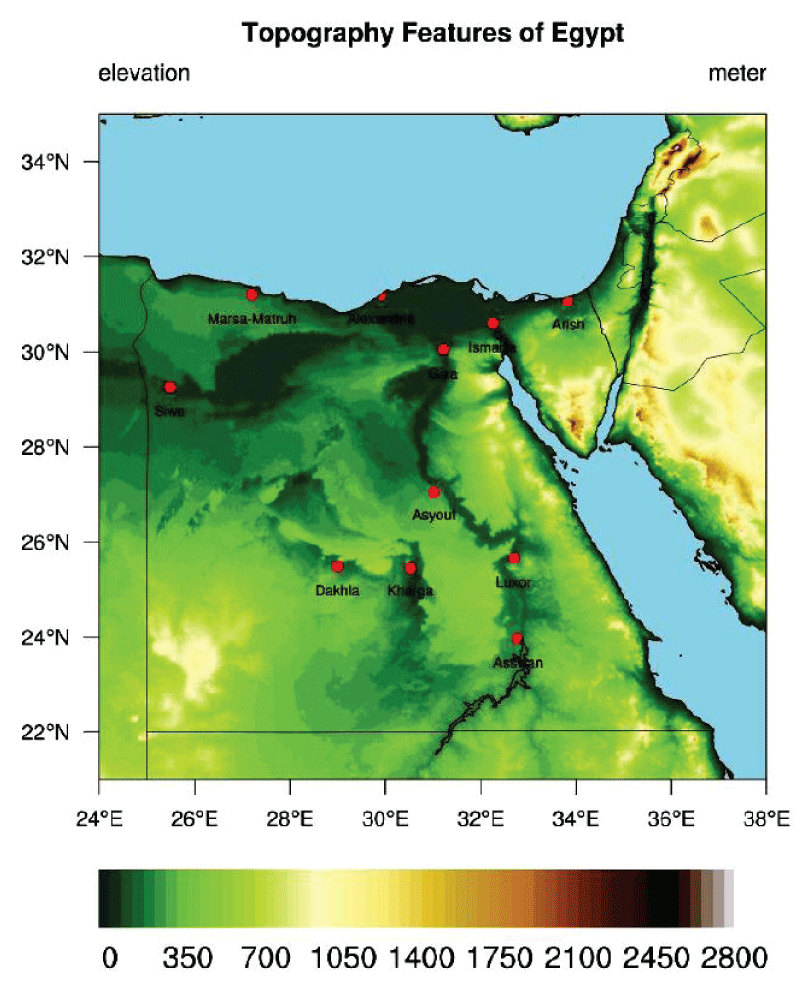
Figure 1: The figure shows the surface elevation of Egypt (in meters). The red dots indicate the location of the ten locations for evaluating the RegCM’s performance.

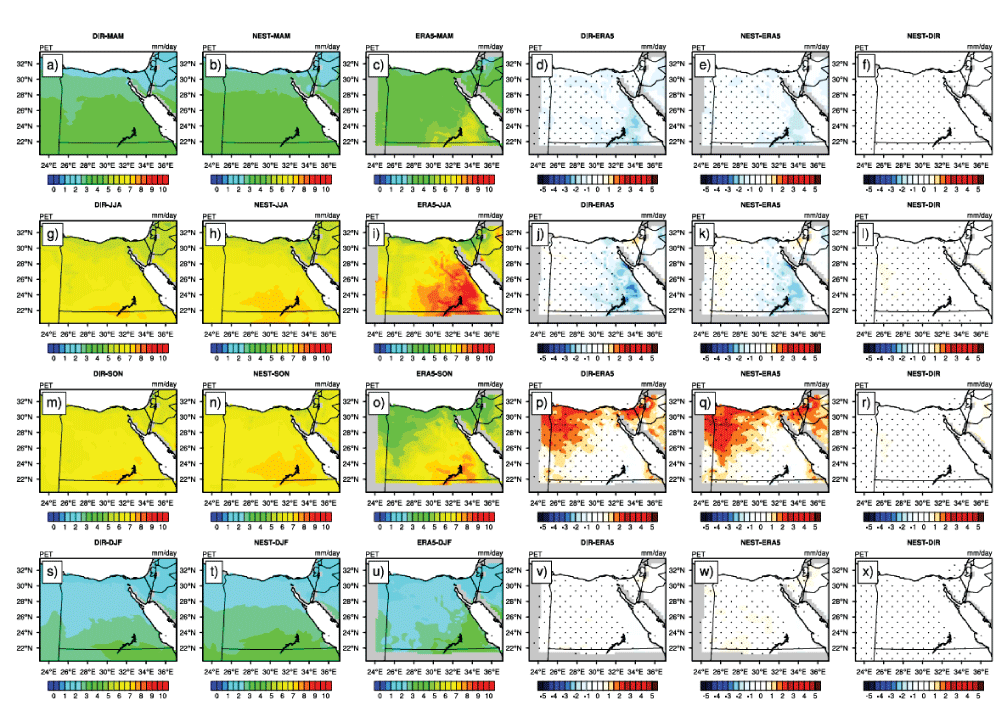
Figure 2: Potential evapotranspiration over the period 1998–2017 (PET; in mm day-1) for MAM season in the first row (a - f); JJA in the second (g - l); SON in the third (m - r); and DJF in the fourth (s - x). For each row, DIR is on the left, followed by NEST; ERA5 is the third from the left, DIR minus ERA5, NEST minus ERA5, and the difference between NEST and DIR. Significant difference/bias is indicated in black dots using a student t-test with alpha equal to 5%.

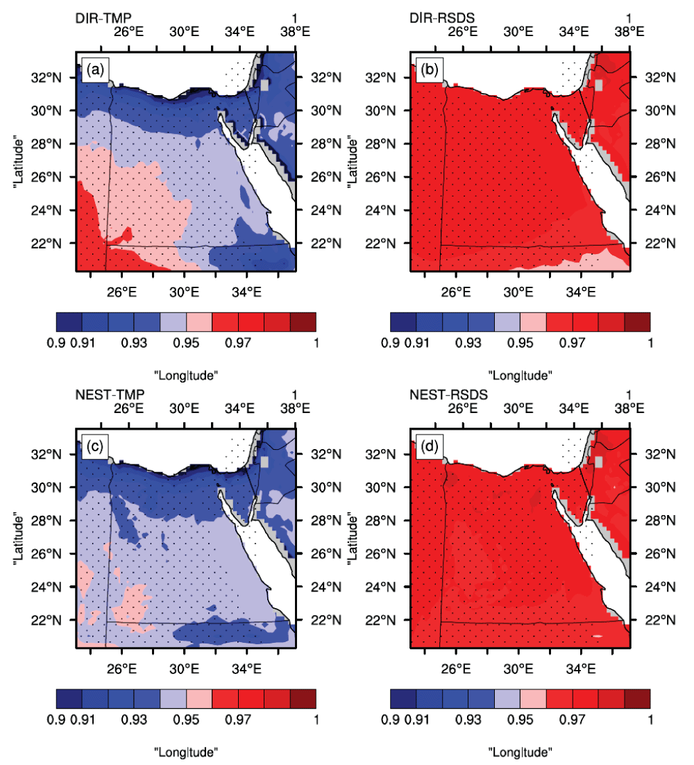
Figure 3: Pearson correlation coefficient for each grid point for DIR (a for TMP), (b for RSDS); NEST (c for TMP), and (d for RSDS). Note that the range of 0.9 and 1 has been chosen after many trials to choose the appropriate range.

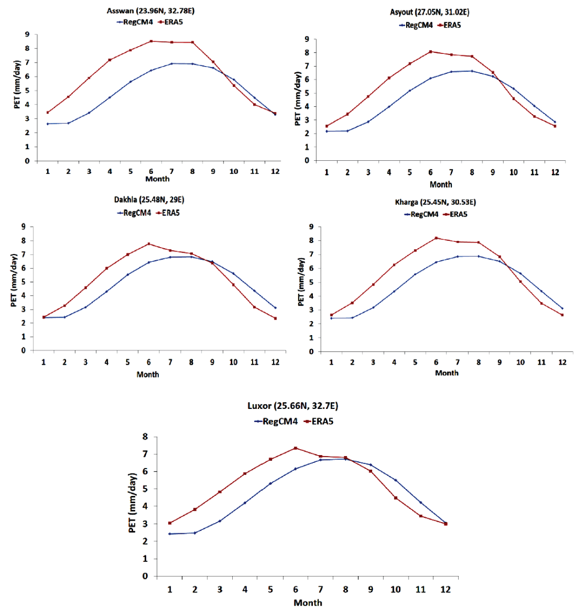
Figure 4: Climatological annual cycle of the simulated PET concerning the ERA5 for the locations: Asswan, Asyout, Dakhla, Kharga, and Luxor.

Leave a Reply

Your email address will not be published. Required fields are marked *